• Skip to content
  • Members Area
    • Login
    • Account
    • Rings Routine
    • Hypertrophy Routine
    • Easy Hamstrings Flexibility
    • Hip Flexibility Program
    • Slackline Program
  • My Training Programs
    • Hip Flexibility (Purchase Here)
    • Easy Hamstrings (Purchase Here)
    • Rings Routine (Purchase Here)
    • Hypertrophy Routine (Purchase Here)
    • /r/bodyweightfitness Routine (Free; Beginners)
    • Bodyweight PPL Split (Free; Intermediate)
    • Slackline Program
  • Articles & Tutorials
    • Fitness Index
    • Nutrition Index
    • Inspirational Index
    • Science Index
      • Human Anatomy Series
      • Human Physiology Series
      • Pharmacology Series
  • About Me
  • Contact Antranik

Antranik.org

Strength & Flexibility Expert

Like! Follow! Subscribe!

  • Facebook
  • Instagram
  • YouTube

Michael D Antonovich Regional Park in Chatsworth

Looking south toward the San Fernando Valley on the left and the Simi Hills on the right with clouds creeping over them during sunset. (Click for high resolution)

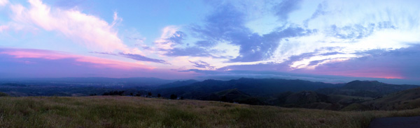
View: 10 out of 10.  Not only is the view pretty nice up here, it is also very tranquil.  Getting to the park requires you to drive into the wilderness and within a few minutes you go from being in the population-dense valley to a very isolated area in the Santa Susana mountain range.

Accessibility: Somewhat easy… somewhat because it requires driving through a mountain for 15-20 minutes then walking up a very steep road.  When you enter the gates to the park, you’ll see a sign that says you have to pay $5 to park.  You have to put $5 in the envelope provided by the box and write down your license # on there and slip it in the box. If a ranger comes and sees you might get ticketed for $50.

Also, the place closes after sunset.  Then you have to walk up this steep road and pass this old abandoned (it’s used for movies nowadays) ranch and keep going up until you get to the helicopter pad.  That’s where the above picture was taken from.  If you were to keep walking up, you could technically get all the way up to the satellite towers and then behind that mountain would be the Santa Clarita mountains and valley, which has to be one incredible view.

Google maps guide: Look at the map below as a guide.

Drive to A and park there.
Walk to B.  B is where the above picture was taken and the view is even more expansive than this.
If you continue up and want to go to C, you will have to walk almost 2 miles up a very steep road and you will get to some communication towers that are at the PEAK of the Santa Susana Mountains.  You’ll be able to see both the Santa Clarita and San Fernando Valley and the mountains surrounding it, and also the Topatopa mountain range. Have water (and sunblock) with you if you are going to go all the way up to the peak!!!

 
View Larger Map

Liked it? Take a second to support Antranik on Patreon!

Want To Get Strong and Flexible? 💪 Check Out My Programs!

Antranik’s Hip Flexibility Program

I've created this hip flexibility program for those that would like to improve their flexibility in an efficient manner, with a follow along video that only … [Read More]

Antranik’s Easy Hamstrings Program

For those who have poor flexibility, tight hamstrings and want a simple program that will help them to get looser in a gentle, non-painful manner. You'll be … [Read More]

Antranik’s Hypertrophy Routine

This training routine is focused largely on increasing strength and muscle mass (aka muscular hypertrophy). If I had to sum up the routine in one fell swoop I … [Read More]

Antranik’s Slackline Program

A comprehensive program that will take someone who has zero slacklining experience to be able to walk longer and higher lines until they can highline, if they … [Read More]

Antranik’s Rings Bodyweight Training Routine

This is for anybody who wants to get strong and have fun with a gymnastics-inspired routine. It is highly bodyweight-exercise oriented (no external weights) and … [Read More]

Latest Instagram Posts

Load More…Follow on Instagram

Contact · Log in